Hello park supporters!
It was great to see many of you at the cove on Saturday night for a night of celebration - and hopefully closure - of our effort to protect that wonderful place.
Commissioner Comegno's Promise to Protect
On Sat., Nov. 17, John Comegno, Chairman of the Burlington County Bridge Commission, updated me on progress concerning the agreement to protect the 50 acres. He said that by the end of the year, he expects to have the agreement written and signed.
Army Corps./DEP meeting on Nov. 20
Last week Fred Stine and I did a file review at the Army Corps. of Engineers offices in Philadelphia. We looked through all of the documents they have pertaining to Palmyra Cove Nature Park and found out some intestesting points, including:
-The Army Corps. knew as early as June that the emergency dredging of the Delaware would begin on August 14. Remember, they didn't tell the public when it would begin until Monday, August 13 at the public information session.
-Over and over again, Army Corp. documents point to the DEP's lack of maintenance on Burlington Island and Hawk Island as the reason the only available dredge cell in the region exists at Palmyra Cove.
-Charley Myers, the Army Corps' Project Manager, and the DEP are meeting on November 20 to discuss a long-term strategy for dumping dredge spoils. Hopefully they will identify and prepare alternative sites.
Check back in a few days to read more of these bullet points as I peruse through the files and add them.
Thanks!
Courtney
Monday, November 19, 2007

Monday, September 24, 2007
Can you be there?
Hello friends,
There are a couple of important meetings this week and your presence will send the message that many people are still focused on the Conservation Easement.
Burlington County Bridge Commission
Wed. Sep. 26 2 p.m.
@ the Bridge Commission
Please come to this monthly meeting to ask if the Bridge Commission has made progress in attaining the Conservation Easement. The Bridge Commission and even the DEP has both expressed their support for the protecting this 5o-acre parcel, so we just have to push it to the top of their agenda.
Wed, Sep. 26 9:30 a.m.
Tim Robinson, Burlington Cty. Soil Conservation District
@ Palmyra Cove Nature Park
I am meeting with Tim Robinson to see how his organization can help us. They have already served Lisa Jackson with a violation for the project because the DEP didn't get prior approval from Soil Conservation. They've also forced the DEP to correct the outflow pipes to decrease the amount of silt flowing back into the river. If you can make it to the meeting that would be great - the more supporters this park has the better, as you know. :)
Also, a couple of people have asked me what to do with yard signs. Clara feels the most effective strategy is for everyone to take the yard signs down until the issue over the conservation easement heats up - then they can put them up again. That would make a stronger statement than leaving them up, I think.
Thank you and I look forward to seeing many of you this week!
There are a couple of important meetings this week and your presence will send the message that many people are still focused on the Conservation Easement.
Burlington County Bridge Commission
Wed. Sep. 26 2 p.m.
@ the Bridge Commission
Please come to this monthly meeting to ask if the Bridge Commission has made progress in attaining the Conservation Easement. The Bridge Commission and even the DEP has both expressed their support for the protecting this 5o-acre parcel, so we just have to push it to the top of their agenda.
Wed, Sep. 26 9:30 a.m.
Tim Robinson, Burlington Cty. Soil Conservation District
@ Palmyra Cove Nature Park
I am meeting with Tim Robinson to see how his organization can help us. They have already served Lisa Jackson with a violation for the project because the DEP didn't get prior approval from Soil Conservation. They've also forced the DEP to correct the outflow pipes to decrease the amount of silt flowing back into the river. If you can make it to the meeting that would be great - the more supporters this park has the better, as you know. :)
Also, a couple of people have asked me what to do with yard signs. Clara feels the most effective strategy is for everyone to take the yard signs down until the issue over the conservation easement heats up - then they can put them up again. That would make a stronger statement than leaving them up, I think.
Thank you and I look forward to seeing many of you this week!
Thursday, August 30, 2007
What's happening at Palmyra Cove?
The Tacony-Palmyra Bridge's warning siren drowns out the screams of crickets; the bridge is about to open. It's 11:30 a.m. and I've just arrived at Palmyra Cove Nature Park. Standing on the beach, I'm hoping to see the McFarland, the U.S. Army Corps. of Engineers dredging barge. I catch a glimpse of yellow at the bridge breaks apart and the two sides rise into the air. It's the McFarland, about to pass through the open bridge. I grab my video camera and zoom in on the monstrous water beast. Through the viewfinder I see the white block letters stamped onto the underbelly of the black behemoth: MCFARLAND.
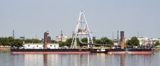
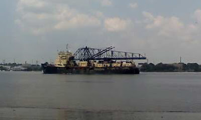 Camera rolling, I watch the monster creep up on the bridge, chugging steadily, and slip through, heading south toward the mooring barge awaiting arrival of its master. A family, three generations of nature lovers, sits on the beach and watches the gliding machine, mesmerized. I hike down the River Trail still stalking my prey; the camera is my weapon of choice. After about 10 minutes the McFarland docks into the mooring barge, the ships seeming to kiss hello as they become one.
 I pick my way through the sand, past tiny footprints that remind me of my own child, and arrive at the drainage pipes. Water gushes heavily - the color of beer or urine - from the pipes into the Delaware River. The air reeks of polluted earth; a concoction of contaminated sand, river water and diesel fuel. A long black pipe stretches into the river from the beach like the giant black tentacle of a kraken. It's marked by a giant round pink buoy. The family has left and the child's footprints washed away. A phrase springs to mind: post-modern dystopia. The juxtaposition of the man-made versus the natural leaves me feeling sick. This is all one messed-up band-aid, a temporary solution to the long-term problem of where to put dredge spoils.
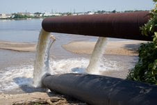 Now I have a problem. The pipes have blocked my hike. This dredging project isn't supposed to stop people from using any of the trails, but I've only been here for 15 minutes and already I'm barred from hiking into the park. Minimal impact project is the phrase they keep throwing around, but I'm trapped. I feel like the great water beast is laughing at me. Then I spot another hiker walking towards me on the other side of the pipes. He hops onto and then over the great black pipe and I compliment his spryness. His name is Kevin and we find out we have a mutual friend: the indefatiguable Fred Stine of the Delaware Riverkeeper Network. (The community of environmentalists is a closely-knit one in this region.) We talk together as we watch the barges and he explains that the McFarland dumps its sand into the great black hose of the mooring barge. The hose, reminiscent of the basilisk in Harry Potter and the Chamber of Secrets, snakes along the river floor and emerges about 150 feet from where we stand on the beach. Serpentine, its great body basks in the hot sun hundreds of feet into the park area formerly known as the desert. I give Kevin CAN's contact info and continue my monitoring mission to the tune of grumbling ships and insect symphonies.
As I follow the beast's tubular body into my beloved park, I am surprised to see vehicles driving on the trails and parked next to the work area. A mound of red gravel had been built on top of the black hose to allow these vehicles to drive to and from the work site over the hose. I turn my eyes to the ground and I see bulldozer tracks. It's churned up the grasslands area near the area where CAN's members have protested two weeks ago. Deep gashes, three inches deep and two inches wide, mark the bulldozer's course. Bushes are crushed beneath the basilisk's body. I straddle the hose to cross over it - it's like sitting on the back of an elephant. I approach the work site and wary workmen cautiously wave hello. The bulldozer dozes; it's the lunch hour. I say hello to the men.
"You were one of those protesters, weren't you? You had your kid with you. I was driving the bulldozers," one of the men ventures.
"Yes, I was and I remember you. I was yelling Save the Cove! at your bulldozer and you got out and told me you were 'just doing your job,'" I said. "Just so you know, we're not against the dredging, we just don't want it dumped here. This is the problem with Jersey - there are too many people and nowhere to put this stuff." Another man walked up and heard the last part of my comment.
He said, " There's nowhere to put it around here. But there are plenty of places farther south down the river, like Pedricktown. That site can hold 2400 acres. The government used to test Nike missiles there and it's owned by the U.S. government." [I have since found out this site is one of the most ecologically vibrant natural places in NJ and must be protected - the worker didn't know what he was talking about.]
I questioned him further. "Why hasn't it been used before?"
"It would take the barge 3 or 4 hours to get down there. It's too time consuming and expensive," he explained. Then he went on to talk about how he heard the the environmentalists really laid Charlie Myers, the Army Corps' project manager, at the Public Information Session on August 13. I smiled proudly and told him I was one of those people.
A minute later, I say good-bye to the workers and turn my eyes to the scene before me. What was the desert is now a cappuchino-colored mud pit. It's heartbreaking. I think I'm going to be sick. I remember my first meeting with CAN; walking across this trail with the three environmental teachers, Suzanne, Anjie and Bernie. They pointed out fox holes and footprints; the area was a rich and diverse ecosystem. Now it has been slathered with wet, contaminated mud. Picture a sandbox after a rainstorm. Trees are waist deep in water. Mud strangles their trunks. Will they survive? Where are the fox now? Elegant yellow leaves fall to the mud floor and get stuck here; the seasons march on, relentlessly.
 Suddenly moving water rushes across the plain, giving the illusion of a stream. It flows into the fragmites, which acts as a natural filter and is one of the reasons this parcel makes such an effective dump site. Darn invasive species. Other workers are milling around and I ask them where the drain pipes are.
"The sluicebox? Follow the orange fence around the bend and it's on the right," one replies.
As I follow the orange fence, I'm struck once again by the almost gothic combination of sounds - insects chirping, the stream's song, and the barge's bass. The park trembles. The muddy desert has changed into a far-reaching field of fragmites. In the distance, I see the same orange fence marking the perimeter of the 20-acre work area. When I get to the sluicebox I see a wooden walkway streatching from the trail to the framed of the sluicebox, which reminds me of an unfinished shed. Two NO TRESPASSING SIGNS warn park users to stay away. The sluicebox structure is 12-foot by 12-foot by 12-foot cube, by my estimation. The floor is covered in mud and I hear water falling. I can't see the pipes but I envision their double gaping mouths, hungry to suck up the river water. I hear the bulldozer roar to life and I feel nauseous again. I see a delicate white butterfly and hear an animal scurrying in the underbrush inside the fence. It gives me a moment of hope that the fox are still around, but then I worry that they're stuck inside the work area.
To the right of this path, near the junction of the Saw Whet trail, lives a young forest. Peering under its canopy, I see birds and insects. This thriving ecosystem gives me hope - it, at least, remains untouched. This is part of the 50 acres CAN helped save.
I decide to walk back to the worksite; as I turn to go I hear a smaller bulldozer approaching from the young forest, driving out of the Saw Whet trail. A second bulldozer. I hike back to the worksite and see a John Deere tractor and I think that modes of transportation are one of the issues that divides "us" from "them." We travel via foot and golf cart; they choose SUVs, trucks, and tractors. There's something so natural and flowing about hiking books and even quiet golf carts. But the sight of these huge, roaring, polluting machines angers me; they don't belong in a nature park.
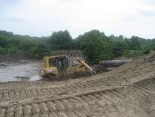 I hike up a little hill, the entrance to the work site, and stand on an overlook. The destruction spreads out before me, tall mounds of mud; flowing polluted water; a bulldozer pushing it toward the drainage pipes. I think about Freeholder Haines letter (See previous blog entry in red): The original vision of this park was for nature and technology (dredge spoils) to coexist peacefully, he wrote. But that was an impossible vision - the two are incompatible. The people who enjoy this park are disgusted by the dredge silt, the bulldozers, the destruction. We have to prevent this from ever happening in the park again. Like any growing, changing, entity, the park has risen above and beyond its original potential. It broke free of man-imposed restraints.
A third bulldozer disturbs my thoughts and I have to scurry to get out of its way as it rumbles toward my perch overlooking the desert. After the bulldozer parks, I pick my way down the trail toward the last checkpoint on my surveillance session, Dragonfly Pond. I want to see for myself if Commissioner Jackson's workmen are honoring her promise to protect the wetlands. This trail has been ripped up by the bulldozers. Have you ever seen the columns icon on MS Word? That's what this trail looks like - two columns of deep wounds on either side of the trail. It's scarred.
I walk down the little hill toward the pond and I'm not prepared for what I see. The pond has swollen - it's dark brown and some strange liquids that resemble diesel fuel are floating on its surface. The path to the right, which used to lead into the desert, is submerged with the same brown liquid. Again, I wonder what's happened to the fox. Last time I was here, at least half a dozen birds were playing and bathing in the pond. Now, there are no birds in sight and I can't even hear any singing. Another SUV drives down the trail above me.
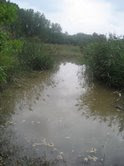 As I descend to get a closer look at the damage on Dragonfly Pond, I heard three loud plops into the water. The frogs are still here. I see a few dragonflies as well. A huge truck drives by. I lean over to look at that strange liquid and more frogs jump into the water; they seem more skittish than usual. Their environment - their world - has been forever altered by humans. Only nature can repair it and I'm confident she'll regenerate, grow, rise again. That nature will recover isn't a possibility - it's a certainty. The park is in her hands now.
 E-mail the author, Courtney McLaughlin at savethecove@gmail.com. Thanks to Bennett Landsman, Dan Homan and Jane Nogaki for taking these wonderful photos.
Wednesday, August 29, 2007
Eyewitness updates and Freeholder Haines' letter
Hello friends,
As August dims to a close, dredge dumping continues in Palmyra Cove Nature Park. Thanks to all of you who have been monitoring the progress of the DEP and Army Corps in the park. Your reports have been both positive and negative. Positive in that the DEP and Army Corps seem conscientious about leaving as minimal an impact as possible. But of course the impact from the work area is roaring and reverberating throughout the park, scaring away the dragonflies from Dragonfly Pond for example. Bulldozers, slicing deep wounds into the trails and desert, thunder loudly and belch great clouds of dirty diesel fuel. It's very, very sad to be in the park while this work is going on, but it's important for us to monitor these actions. Please keep up the good surveillance - photos are especially important.
Here are some eyewitness accounts and updates:
-Jane Nogaki of the NJ Environmental Confederation:
"I went to the Cove sunday afternoon after reading Dick Pearsall's story in the courier post. There was water running out of the discharge pipes to the river, but no active pumping into the basin at the time I was there - around 1 -2 p.m., but a bulldozer inside the 2 acre area moving soil around pushing it up to the edges and building up the bermed sides, under the pipe into the dredge spoil site. As I left, the two dredge boats/barges were pulling up to the site getting ready to drop another barge load. I took photos, attached, and one thing I notices was Dragonfly pond seems siltier than usual, and an absence of dragonflies. Have you noticed that? I do want to stay involved to help you whenever I can. Lisa Jackson told me last Sunday at the Clearwater Festival that she needs to find a more permanent dredging site pronto, and we need to hold her to that, so this doesn't go on and on."
-Bernie, Cinnaminson - a teacher at the cove:
"I took a walk through the park today (Sat) with a friend and took some pictures, most of which are already shown here. There were quite a few dragonflies at the pond along with about 8 turtles sunning themselves on two small logs. I was shocked to see how far up the water had come. Further into the park we even managed to see two deer. I do, however, know where the foxes (at least some of them) are. My friend who was with me lives in Riverfront (her place is right on the river) and she said that some of them are there. I guess the photographer from Channel 3 and I were probably the last ones in the desert. I took him to see the fox holes just before the bulldozers showed up."
-Marlene, Delanco:
"I am glad we had some impact...though it is so disappointing to lose any of that lovely site. Everytime the Macfarland goes past my house my stomach turns. It must make 20 trips through the day and night."
-We are continuing to press for a Conservation Easement to permanently protect the adjacent 50 acres, although we are no longer sure that's the right term. At the Bridge Commission meeting last week, Fred Stine of the Delaware Riverkeeper Network, Chris Jage of the NJ Conservation Foundation and myself asked the Bridge Commission how progress is coming on the agreement to preserve the 50 acres. Commissioner John Comegno thanked us - and asked me to share his gratitude with you - for all of the work we have done. Although we lost 20 acres, we managed to help save a large park of the park. So it's both a victory and a defeat. Comegno and JJ expressed their desire to permanently preserve the 50-acre-parcel, but said there's some "legal language" that has to be worked out first. This may have something to do with the 1998 agreement that created the nature park.
-Joann reached out to Burlington Freeholder Haines, imploring him to help save the 50 acres. He responded with this letter:
This is in response to your email requesting that the Board of Chosen Freeholders assist in preserving the Palmyra Cove Nature Park.
As you may know, the State of New Jersey is the owner of the majority of the land that makes up the Nature Park. This land was created through the deposition of dredge materials dating as far back as the 1930’s and is designated as tidelands because it is now or was flowed by the mean high tide. The State Constitution vests the authority to sell or lease state owned tidelands with the Tidelands Resource Council, known at one time as the Board of Navigational Commissioners. A Congressionally authorized pact exists between the States of New Jersey and Pennsylvania whereby each state is required to make lands available for dredge material as may be required to maintain the Delaware for navigation. It is the policy of the Tidelands Resource Council that it will not sell or lease land that has been designated by the State for dredge disposition. As you can imagine, these sites are limited. Three sites exist in Burlington County – Palmyra Cove, Hawk Island and Burlington Island.
In the early 1990s, Palmyra area residents became interested in creating a nature park at Palmyra Cove and requested the Freeholders assistance in doing so. Understanding that the State would not consider sale of this land, an application was made to the Tidelands Resource Council to seek approval to use the cove area for a park through assignment of a management rights agreement. This type of agreement would allow a public entity to use of these State controlled lands, generally without charge, for an extended period of time. In 1996, the Tidelands Resource Council agreed to a management rights agreement for Palmyra Cove for a 30 year period subject to the continuing use of the site as a Dredge Management Area. The management rights agreement, executed in 1998, is a three party agreement between the State of New Jersey, the Burlington County Board of Chosen Freeholders and the Burlington County Bridge Commission. Although the agreement does not encompass the 70 acre dredge disposal site, the County and Bridge Commission agreed when they signed the agreement that they would not interfere with the dredge spoils operation within this designated area. Furthermore, the agreement recognizes that the primary use of the tidelands is for dredge disposal and if it becomes necessary to use additional land within the confines of the Management Rights Agreement, the assigned lands shall be vacated.
As I stated above, it was understood from the outset of this project that the State would continue to need this area for dredge disposition. In view of this, the 1994 Concept Plan for the nature park prepared by the Bridge Commission recommended that “information booklets should be prepared explaining the (dredge) processes and their importance” and informational signs be posted along the trail system. The unique partnership between the State, Bridge Commission and County was viewed as an opportunity to demonstrate that two diverse uses of the site could co-exist and to attract funding to construct the nature center. One such funding application states that “[T]his project should be viewed as a prototype for other areas along the Delaware River where a once perceived negative perception of a dredge material site can be shown to work in harmony with nature, be an asset to the community and provide an economic benefit to the area.”
Maintenance of the navigational channels of the Delaware is important to both commercial shipping and recreational boating. As you point out, the Nature Center is enjoyed by many and is home to numerous species of animals and migratory birds. I continue to believe that the Nature Park and the dredging operation can co-exist and that the Freeholders have taken the appropriate actions to balance the needs and wishes of all involved.
Sincerely yours,
William S. Haines, Jr.
Freeholder
As August dims to a close, dredge dumping continues in Palmyra Cove Nature Park. Thanks to all of you who have been monitoring the progress of the DEP and Army Corps in the park. Your reports have been both positive and negative. Positive in that the DEP and Army Corps seem conscientious about leaving as minimal an impact as possible. But of course the impact from the work area is roaring and reverberating throughout the park, scaring away the dragonflies from Dragonfly Pond for example. Bulldozers, slicing deep wounds into the trails and desert, thunder loudly and belch great clouds of dirty diesel fuel. It's very, very sad to be in the park while this work is going on, but it's important for us to monitor these actions. Please keep up the good surveillance - photos are especially important.
Here are some eyewitness accounts and updates:
-Jane Nogaki of the NJ Environmental Confederation:
"I went to the Cove sunday afternoon after reading Dick Pearsall's story in the courier post. There was water running out of the discharge pipes to the river, but no active pumping into the basin at the time I was there - around 1 -2 p.m., but a bulldozer inside the 2 acre area moving soil around pushing it up to the edges and building up the bermed sides, under the pipe into the dredge spoil site. As I left, the two dredge boats/barges were pulling up to the site getting ready to drop another barge load. I took photos, attached, and one thing I notices was Dragonfly pond seems siltier than usual, and an absence of dragonflies. Have you noticed that? I do want to stay involved to help you whenever I can. Lisa Jackson told me last Sunday at the Clearwater Festival that she needs to find a more permanent dredging site pronto, and we need to hold her to that, so this doesn't go on and on."
-Bernie, Cinnaminson - a teacher at the cove:
"I took a walk through the park today (Sat) with a friend and took some pictures, most of which are already shown here. There were quite a few dragonflies at the pond along with about 8 turtles sunning themselves on two small logs. I was shocked to see how far up the water had come. Further into the park we even managed to see two deer. I do, however, know where the foxes (at least some of them) are. My friend who was with me lives in Riverfront (her place is right on the river) and she said that some of them are there. I guess the photographer from Channel 3 and I were probably the last ones in the desert. I took him to see the fox holes just before the bulldozers showed up."
-Marlene, Delanco:
"I am glad we had some impact...though it is so disappointing to lose any of that lovely site. Everytime the Macfarland goes past my house my stomach turns. It must make 20 trips through the day and night."
-We are continuing to press for a Conservation Easement to permanently protect the adjacent 50 acres, although we are no longer sure that's the right term. At the Bridge Commission meeting last week, Fred Stine of the Delaware Riverkeeper Network, Chris Jage of the NJ Conservation Foundation and myself asked the Bridge Commission how progress is coming on the agreement to preserve the 50 acres. Commissioner John Comegno thanked us - and asked me to share his gratitude with you - for all of the work we have done. Although we lost 20 acres, we managed to help save a large park of the park. So it's both a victory and a defeat. Comegno and JJ expressed their desire to permanently preserve the 50-acre-parcel, but said there's some "legal language" that has to be worked out first. This may have something to do with the 1998 agreement that created the nature park.
-Joann reached out to Burlington Freeholder Haines, imploring him to help save the 50 acres. He responded with this letter:
This is in response to your email requesting that the Board of Chosen Freeholders assist in preserving the Palmyra Cove Nature Park.
As you may know, the State of New Jersey is the owner of the majority of the land that makes up the Nature Park. This land was created through the deposition of dredge materials dating as far back as the 1930’s and is designated as tidelands because it is now or was flowed by the mean high tide. The State Constitution vests the authority to sell or lease state owned tidelands with the Tidelands Resource Council, known at one time as the Board of Navigational Commissioners. A Congressionally authorized pact exists between the States of New Jersey and Pennsylvania whereby each state is required to make lands available for dredge material as may be required to maintain the Delaware for navigation. It is the policy of the Tidelands Resource Council that it will not sell or lease land that has been designated by the State for dredge disposition. As you can imagine, these sites are limited. Three sites exist in Burlington County – Palmyra Cove, Hawk Island and Burlington Island.
In the early 1990s, Palmyra area residents became interested in creating a nature park at Palmyra Cove and requested the Freeholders assistance in doing so. Understanding that the State would not consider sale of this land, an application was made to the Tidelands Resource Council to seek approval to use the cove area for a park through assignment of a management rights agreement. This type of agreement would allow a public entity to use of these State controlled lands, generally without charge, for an extended period of time. In 1996, the Tidelands Resource Council agreed to a management rights agreement for Palmyra Cove for a 30 year period subject to the continuing use of the site as a Dredge Management Area. The management rights agreement, executed in 1998, is a three party agreement between the State of New Jersey, the Burlington County Board of Chosen Freeholders and the Burlington County Bridge Commission. Although the agreement does not encompass the 70 acre dredge disposal site, the County and Bridge Commission agreed when they signed the agreement that they would not interfere with the dredge spoils operation within this designated area. Furthermore, the agreement recognizes that the primary use of the tidelands is for dredge disposal and if it becomes necessary to use additional land within the confines of the Management Rights Agreement, the assigned lands shall be vacated.
As I stated above, it was understood from the outset of this project that the State would continue to need this area for dredge disposition. In view of this, the 1994 Concept Plan for the nature park prepared by the Bridge Commission recommended that “information booklets should be prepared explaining the (dredge) processes and their importance” and informational signs be posted along the trail system. The unique partnership between the State, Bridge Commission and County was viewed as an opportunity to demonstrate that two diverse uses of the site could co-exist and to attract funding to construct the nature center. One such funding application states that “[T]his project should be viewed as a prototype for other areas along the Delaware River where a once perceived negative perception of a dredge material site can be shown to work in harmony with nature, be an asset to the community and provide an economic benefit to the area.”
Maintenance of the navigational channels of the Delaware is important to both commercial shipping and recreational boating. As you point out, the Nature Center is enjoyed by many and is home to numerous species of animals and migratory birds. I continue to believe that the Nature Park and the dredging operation can co-exist and that the Freeholders have taken the appropriate actions to balance the needs and wishes of all involved.
Sincerely yours,
William S. Haines, Jr.
Freeholder
Subscribe to:
Posts (Atom)